Occoneechee State Park
| Occoneechee State Park, Virginia, USA | |
|---|---|
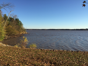
 The John H. Kerr Reservoir, better known as Buggs Island Lake, at Occoneechee State Park in Virginia | |
| Coordinates | 36°37′33.963″N 78°31′26.7636″W / 36.62610083°N 78.524101000°W |
| Area | 2,698 acres (1,092 ha) |
| Established | 1968 |
| Governing body | Virginia Department of Conservation and Recreation |
Occoneechee State Park is a state park near Clarksville, Virginia, located along Buggs Island Lake. Occoneechee State Park is 2,698 acres in size. Its name reflects the Occaneechi Indians, who lived on (and traded from) an island in the Roanoke River near its confluence with the Dan River, which was flooded by the creation of the Kerr Lake reservoir in 1952.
History
[edit]Bacon's Rebellion abruptly ended their prominence in 1676. This armed rebellion is considered to be the first to occur in the New World. It began when Nathaniel Bacon’s plantation was raided by Susquehannock Indians, who had been displaced from their home to the north. Bacon asked Virginia Gov. Berkley to raise a militia and retaliate. Berkley denied the request so Bacon raised a militia, in violation of the governor’s wishes."[1]
Facilities
[edit]Cabins, yurts, equestrian and primitive campsites
Hiking trails
Splash park
Marina with fueling facility
References
[edit]
- State parks of Virginia
- Parks in Halifax County, Virginia
- Parks in Mecklenburg County, Virginia
- Native American museums in Virginia
- Museums in Mecklenburg County, Virginia
- Protected areas established in 1968
- 1968 establishments in Virginia
- Occaneechi
- Virginia protected area stubs
- Southern Virginia geography stubs


